Mount Huang
Huangshan, integrating the essence of famous mountains in China, showcases various beautiful landscapes. It is the only mountainous scenic area in China that stands alongside the Yellow River, Yangtze River, and the Great Wall. Huangshan boasts a magnificent array of peaks, numerous deep valleys, and is renowned worldwide for its unique pine trees, peculiar rocks, sea of clouds, hot springs, and winter snow. Its majestic mountainous terrain and misty scenery have earned it the title of the “leader among famous mountains.”
Huangshan presents picturesque views throughout the four seasons. In spring, the mountains are adorned with lush greenery, vibrant mountain flowers, and the delicate fragrance of blooming azaleas. In summer, the peaks of Huangshan are enveloped in a sea of verdant hues, accompanied by refreshing mountain breezes, making it a popular summer retreat. Autumn transforms Huangshan into an enchanting painting, displaying a kaleidoscope of colors that captivate the eyes with its beauty. Winter unveils a rare spectacle of snow-capped peaks, misty waterfalls, and seas of clouds, revealing a breathtaking beauty that is beyond imagination until seen firsthand.
Practical Information
- Chinese Name: 黄山
- Location: Tangkou Town, Huangshan District, Huangshan City, Anhui Province
- Elevation: 1800 meters (5905 feet)
- Ticket Prices: December 20 to January 20: 150 RMB; January 21 to December 19: 190 RMB
- Best Time to Visit: April to November
- Recommended Travel Duration: 1-3 days
Unique Features and Natural Beauty
Discover the wonders of Huangshan in this captivating guide. Explore unique pine trees, peculiar rock formations, breathtaking sea of clouds, and rejuvenating hot springs. Immerse yourself in the natural beauty of this enchanting mountain.
Unique Pine Trees
There are many pine trees on Huangshan, and most of them have unique appearances. They are known for their distinctive “welcoming” shapes. Some stand alone on mountain peaks, while others grow on steep cliffs. It can be said that every pine tree on Huangshan is extraordinary. One particular tree, measuring 10 meters (33 feet) tall, earned its name because it resembles a person standing with outstretched arms, as if welcoming visitors from afar. This tree has become a popular spot for tourists to take photos.
Peculiar Rocks
The rock formations on Huangshan come in various shapes, some resembling humans and others resembling animals. The forms are lifelike, and what they resemble can vary depending on the viewing angle. Among the most famous formations are the Flying Stone, Monkey Watching the Sea, and Squirrel Jumping to the Sky.
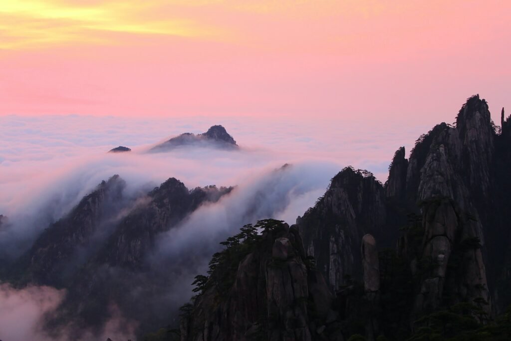
Sea of Clouds
If the weather is suitable during your visit, standing on the mountain gives you the feeling of being in a fairyland, with vast clouds beneath your feet. Particularly spectacular are the “Sea of Rosy Clouds” during clear skies after rain or snowfall, and the sunrise or sunset views. The mountain is divided into different “seas” based on the direction of cloud distribution, such as the Eastern Sea, Southern Sea, Western Sea, Northern Sea, and Heavenly Sea.
Hot Springs
The hot springs, known as “Lingquan” in ancient times, gush out from the foothills of Ziyun Peak, facing Peach Blossom Peak across the stream. According to legend, it is said that Huangdi, the Yellow Emperor, ascended to heaven after bathing in the hot springs of Huangshan for 49 days. When you are exhausted from climbing the mountain, you can enjoy the hot springs located halfway up the mountain. They can be consumed or used for bathing, and they provide great benefits to human health.
Best Tour Routes
Discover the best tour routes to explore the mesmerizing Huangshan (Yellow Mountain). From convenient one-day options to leisurely two-day journeys, these routes offer unique advantages and showcase the most remarkable sights. Embark on an unforgettable adventure, immersing yourself in the scenic wonders of Huangshan.
Route 1:
Take the Taiping Cableway from the North Gate to go up the mountain, visit Feilai Stone, Guangming Peak, and the Welcome Pine, then take the Yuping Cableway from the Front Mountain to go down.
Advantages: This route is relatively short, making it easy to plan for a one-day trip. You can experience most of the scenic spots on Huangshan.
Disadvantages: If you’re driving, you have to arrange how to get the car.
Route 2:
Take the Yungu Cableway from the Back Mountain to go up the mountain, visit Guangming Peak and the Welcome Pine, then take the Yuping Cableway from the Front Mountain to go down.
Advantages: This is the shortest route for going up the back and down the front. If you start early, you’ll have time to detour to Shixin Peak.
Disadvantages: The section from Bai’e Ridge to Guangming Peak doesn’t offer any particularly special scenery, and it can be tiring. You’ll miss out on attractions like Paiyun Pavilion, Feilai Stone, and Echo Wall.
Route 3:
Take the Yungu Cableway from the Back Mountain to go up the mountain, visit Shixin Peak, Feilai Stone, Guangming Peak, Lotus Peak, and the Welcome Pine, then take the Yuping Cableway from the Front Mountain to go down.
Advantages: This is a classic two-day tour route that is also suitable for families with children. On the first day, you can see all the scenery on the back mountain and stay there to witness both sunrise and sunset. On the second day, you’ll experience a completely different landscape on the front mountain, appreciating the grandeur of Huangshan.
Disadvantages: There are no major drawbacks, but the section from Paiyun Pavilion to Guangming Peak can be a bit tiring.
Route 4:
Take the Yuping Cableway from the Front Mountain to go up the mountain, visit the Welcome Pine, Lotus Peak, Guangming Peak, Feilai Stone, West Sea Grand Canyon, Guangming Peak, Bai’e Ridge, and Shixin Peak, then take the Yungu Cableway from the Back Mountain to go down.
Advantages: You can see almost all the scenic spots on this route. If you stay at Guangming Peak, you can enjoy both sunrise and sunset. You won’t backtrack, and the itinerary for the second day is shorter, making it perfect for those who need to return in the afternoon.
Disadvantages: The first day is tight on time, so you need to go up the mountain early.
Essential Tips for a Safe and Enjoyable Visit
Ensure a safe and enjoyable trip to Huangshan with these tips. Bring enough water and food, be weather-conscious, choose accommodation wisely, and prioritize safety on the mountain paths. Maximize your experience in Huangshan with these essential guidelines.
Prepare some water and food
Unlike cities, there are not many shops and supermarkets within the Huangshan Scenic Area. Visitors need to prepare enough water and food in advance. At the same time, it is important not to litter in the scenic area and make sure to dispose of trash in designated bins.
Pay attention to weather changes
Huangshan has a subtropical humid monsoon climate, and the weather can be unpredictable, especially in high-altitude areas. Visitors should adjust their equipment according to the weather forecast and avoid encountering severe weather conditions.
Accommodation
If you want to watch the sunrise on the mountain, you can rent a tent or book a hotel, but the prices are relatively high. If you don’t plan to watch the sunrise, there are many hotels at the foot of the mountain with more affordable prices.
Safety first
The mountain paths in Huangshan are steep, and visitors need to proceed with caution. Avoid climbing railings and trees to prevent accidents.
Mount Tai
Mount Tai, known as the “Supreme of the Five Sacred Mountains,” has been infused with the spirit, culture, and human landscape of China for thousands of years. Mount Tai is more than just a mountain; when we climb Mount Tai, we ascend a sentiment. The Chinese people’s sentiment toward Mount Tai has existed since ancient times. Confucius’ phrase “To view the world from Mount Tai” has had a profound influence, leading numerous scholars and literati of later generations to come here for sightseeing. The scenery of Mount Tai may not be as breathtaking and extraordinary as that of Huangshan or Zhangjiajie, but those who appreciate history and culture have a special fondness for Mount Tai.
Of course, the greatest accolade of Mount Tai lies in its status as the place where emperors of past dynasties performed imperial sacrifices, making it the “National Mountain” in the hearts of the Chinese people. Mount Tai has witnessed the inheritance of the Chinese civilization for five thousand years, symbolizing the prosperity of the nation and the survival of the ethnic group. It carries a rich geographical, historical, and cultural significance and was considered by ancient people as a heavenly place “directly linked to the imperial throne.” It has become a sacred mountain revered by the common people and a site for emperors’ worship. There is a saying that “As long as Mount Tai is safe, the whole world is at peace.”

Practical Information
- Chinese Name: 泰山
- Location: Hongmen Road, Taishan District, Tai’an City, Shandong Province
- Elevation: 1532.7 meters (5036 feet)
- Ticket Prices: April 1 to November 30: 140 RMB, December 1 to March 31: 110 RMB
- Best Time to Visit: April to November
- Recommended Travel Duration: 1-2 days
Unique Features and Natural Beauty
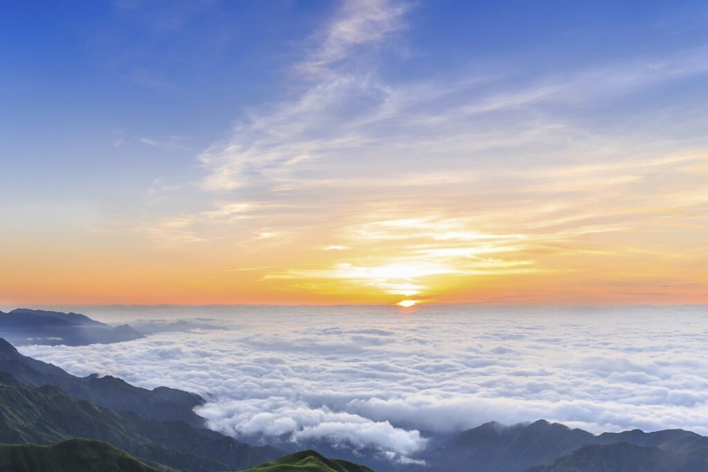
Mount Tai unveils a mesmerizing display of natural wonders. Witness the magnificent sunrise, the ethereal Sea of Clouds, the enchanting Evening Glow, and the captivating Yellow River Golden Belt. Explore these breathtaking marvels and immerse yourself in Mount Tai’s awe-inspiring beauty.
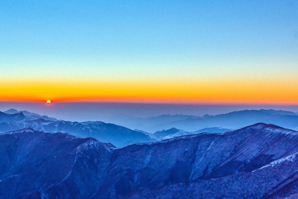
Mount Tai Sunrise
The sunrise at Mount Tai is magnificent and deeply moving. It is one of the spectacular sights at the summit and an important symbol of Mount Tai. As the first rays of sunlight break through the darkness before dawn, the eastern sky transforms from pitch black to a pale white and gradually turns red, eventually shining with a dazzling golden hue, radiating countless rays of light. Finally, a fiery ball emerges from the horizon, soaring into the sky. This entire process resembles a skillful magician, rapidly transforming into a myriad of colorful and captivating scenes, leaving viewers in awe.
Sea of Clouds and Jade Disk
The Sea of Clouds is another marvel at the summit of Mount Tai. In summer, after rainfall clears, abundant water vapor evaporates and rises. Combined with warm air from the sea controlled by high-pressure airflow at an altitude of around 1,500 meters, a windless day at the summit reveals vast stretches of white clouds, resembling a massive jade disk suspended between heaven and earth. Distant mountains are engulfed by the mist and clouds, with only a few peaks peeking through. Visitors nearby seem to walk on the clouds and ride the fog, as if they have arrived in a celestial realm.
Evening Glow
When the rain clears, the sky becomes clear, and the setting sun descends in the west, a stroll to the peak of Mount Tai offers a view of the western sky. There, remnants of clouds resemble peaks and ranges, with golden beams of light piercing through the clouds and mist, illuminating the earth. The evening glow casts a golden edge on the cloud-covered peaks, shimmering like precious treasures. “Who holds the colorful brush to paint the vast sky, with deep yellows and bright reds.”
Yellow River Golden Belt
On a clear day with a setting sun, if you gaze into the northwest of Mount Tai, at the end of the layered peaks, you may witness the Yellow River shining like a golden ribbon. Sometimes, the river reflects onto the sky, creating mirages known as the “Yellow River Golden Belt.” The river glistens with shimmering waves, alternating between silver and yellow, resembling a pathway of gold and silver extending from the southwest to the northeast, reaching the boundary between heaven and earth.
Best Tour Routes
Explore Mount Tai through four remarkable hiking routes, showcasing cultural treasures, convenience, and serene natural beauty. Choose your path and discover the captivating allure of Mount Tai.
Route 1: Middle Route of Mount Tai - The Classic Hiking Route
Dai Temple (Entrance fee: 30 yuan/person) – Daizong Archway – Hongmen Palace – Wanxianlou (Ticket Office: 125 yuan/person) – Doumu Palace – Jingshi Valley – Hutian Pavilion – Huimaling – Zhongtianmen – Kuaihuo Sanli – Yunbu Bridge – Wudafu Pine – Shibaipan – Nantianmen – Tianjie – Bixia Temple – Tang Moya – Wuyue Duzun – Yuhuangding – Gongbei Shi
This hiking route starts from the Dai Temple and is the most concentrated area of cultural and natural landscapes on Mount Tai, making it the essence of Mount Tai. The total distance is 9.5 kilometers, with over 7,000 steps and hardly any flat paths between the foot of the mountain and the summit. It has been the path of emperors’ pilgrimage throughout history and is also known as the Imperial Path of Mount Tai. Along the way, there are lush trees, winding steps, magnificent peaks, and numerous cultural relics, including eight ancient temples, over 200 stone tablets, and more than 300 cliff carvings, allowing visitors to fully experience the charm of traditional Chinese culture.
Tips of Route 1
- For first-time climbers, it is highly recommended to start hiking from this route. If you haven’t hiked this route, it cannot be considered a true visit to Mount Tai.
- It takes approximately 4-6 hours for adults to walk from Hongmen to the summit. Alternatively, you can start the tour from the Dai Temple, which requires an additional 1-2 hours for sightseeing.
- This route can be physically and mentally challenging if you choose to hike the entire way. If you feel exhausted during the climb, you can take the cable car from Zhongtianmen to the summit.
Route 2: West Route of Mount Tai - The Easiest Hiking Route
Tianwai Village (Ticket Office: 125 yuan/person; Shuttle Bus: 30 yuan/person) – Longtan Reservoir – Bailong Pool – Heilongtan – Zhulin Temple – Huangxi River Reservoir – Shanziya – Aolaifeng – Zhongtianmen – Cable Car (100 yuan/person) – Nantianmen – Bixia Temple – Yuhuangding
This route starts from the Tianwai Village Square and is the most convenient, time-saving, and effortless hiking route. The hiking route is divided into two sections: the first section is a mountain road from Tianwai Village to Zhongtianmen halfway up the mountain, covering a distance of 14.35 kilometers. The tourist bus operates at approximately 30-minute intervals, allowing passengers to enjoy the beautiful scenery and historical sites along the way. The second section is from Zhongtianmen to the summit, where you can choose to hike (approximately 2 hours) or take the cable car (approximately 15 minutes).
Tip of Route 2
- Although this route is convenient and easy, it sacrifices many scenic spots. It is recommended to walk from Zhongtianmen to the summit after taking the bus to enjoy more beautiful views of Mount Tai.
- This route is relatively more suitable for families with children or elderly individuals.
Route 3: Tianzhu Peak - The Most Serene and Natural Hiking Route
Tianzhu Peak (Ticket Office: 125 yuan/person) – Wangtianmen – Zimei Pine – Small Tianzhu Peak – Niangniang Temple – Cable Car (One-way: 20 yuan/person) – Yuhuangding
This route starts from Tianzhu Peak, located in the Saozhou valley at the northeast foot of Mount Tai, spanning a distance of 5.4 kilometers. Here, you will find stunning peaks and picturesque rock formations, comparable to the natural beauty of Zhangjiajie. The pinnacle of Tianzhufeng is named after a pine tree that resembles the flame of a candle when viewed from a distance. This route is the least developed scenic area on Mount Tai, maintaining its original simplicity and natural charm, making it an exceptional part of Mount Tai. It is recommended for independent travelers who can choose this route for descending the mountain, avoiding retracing their steps and allowing for a more comprehensive appreciation of the scenic beauty of Mount Tai.
Tips of Route 3
The tourist services and facilities along this route are relatively limited compared to the previous two hiking routes. If you choose to go up and down this route, it is advisable to bring your own food and water.
Route 4: Taohuayu - The Most Romantic Hiking Trail
Taohuayu (Ticket Office: 125 yuan/person; Shuttle Bus: 30 yuan/person) – Diaoyutai – Bifeng Temple – Caishi Stream – Chilin Stream – Hongyu Canyon – Taohuayuan Cable Car (One-way: 100 yuan/person)
This route starts at Taohuayu, located in the western foothills of Mount Tai. During springtime, the mountains are adorned with beautiful blooming peach blossoms, creating a particularly romantic atmosphere. Please note that this hiking location is quite far from the city center and is only suitable for self-driving tourists. It is not recommended for regular independent travelers to choose this route.
Tips of Route 4
The cable car has a significant elevation difference from the ground. Guests who are afraid of heights or have heart conditions are not recommended to take the Taohuayuan Cable Car.
Essential Tips for Night Hiking on Mount Tai
Experience the thrill of night hiking on Mount Tai. Start from “Hongmen,” witness the sunrise, rent a military coat, bring backup power, and find restrooms along the way. Prepare for an unforgettable nocturnal adventure.
Night Hiking on Mount Tai
Start the hike from the “Hongmen” entrance and reach the mountaintop in approximately 6 hours, where you can wait for a moment to witness the sunrise. There are many visitors who begin their hike from the “Hongmen” entrance during midnight, so there is no need to worry about safety. Additionally, you can enjoy the night view of Tai’an City from the halfway point of the mountain.
Military Coat Rental
A military coat is essential for night hiking on Mount Tai. There are booths available for renting military coats at the base and the mountaintop. The rental fee is around 10 yuan per coat and includes a moisture-proof pad.
Backup Power Supply
Due to the slightly lower temperatures at the mountaintop, the performance of digital devices such as cameras and mobile phones may be affected by the cold, causing the battery to drain quickly. It is recommended to fully charge the batteries in advance or carry backup power supplies.
Restrooms
There are over 50 restrooms located throughout the mountain, with an average distance of around 500 meters between them. Restrooms with green signs are free of charge, while those with red signs are privately operated and require a fee of around 1 yuan per person for usage.
Mount Lu
Mount Lu is primarily known for its magnificence, uniqueness, peril, and beauty, earning it the reputation of being “the unparalleled marvel of the world.” It is not only a 5A-level scenic area in China but also a UNESCO World Heritage site. Additionally, it is recognized as one of the top four summer resorts in China. The waterfalls of Mount Lu are also among the three most spectacular in the world, characterized by their abundant water flow and large drops.
Since ancient times, Mount Lu has been a beloved place for literati and scholars. One of the most famous poetic lines about Mount Lu is Su Shi’s “I can’t see the true face of Mount Lu, but I know I’m in it.” Moreover, Li Bai wrote, “A thousand-foot waterfall plunges straight down, as if the Milky Way has fallen from the sky.” The mountain’s history, cultural significance, and popularity among eminent figures have garnered admiration from people worldwide.
Practical Information
- Chinese Name: 庐山
- Location: Lushan District, Jiujiang City, northern Jiangxi Province
- Elevation: 1,474 meters (4,836 feet)
- Ticket Prices: Entrance fee: 160 yuan/person + Sightseeing bus: 90 yuan/person (valid for 7 days)
- Best Time to Visit: March to October
- Recommended Travel Duration: 2-3 days
Unique Features and Natural Beauty
Experience the wonders of Mount Lu in China: Sandiequan waterfall, sunrise vistas from Wulao Peak, the captivating Hanpokou gorge, the architectural marvel of Guling, and the natural beauty of Xianrendong cave. Discover the enchantment of Mount Lu’s landscapes.
Sandiequan
A triple-tier waterfall, is located below Wulao Peak. The cascading waterfall flows down the steep cliffs in three levels, with a total drop of 155 meters, presenting a magnificent sight. It is renowned as the top scenic spot in Mount Lu. Locals claim that if you haven’t seen Sandiequan, you can’t say you’ve been to Mount Lu.
Wulao Peak
The best spot for watching the sunrise, is situated in the southeast of Mount Lu, connected to Poyang Lake. With an elevation of over 1,430 meters, Wulao Peak stands tall, resembling five old men sitting side by side, hence its name. The fourth peak offers the best view, allowing you to overlook the scenery beneath Mount Lu. Additionally, it is the prime location for witnessing the sunrise in Mount Lu.
Hanpokou
Devouring mountains and rivers, lies in the southeast of Mount Lu. It is a massive gorge formed by two opposing mountains. When the sun rises vigorously from the lake’s surface, everything around is immersed in a dazzling red glow, creating a breathtaking spectacle. The carved tower on Hanpokou’s mountaintop is the best vantage point for watching the sunrise.
Guling
A landscape of high-altitude buildings, is located at the center of Mount Lu. Surrounded by mountains on three sides and overlooking a valley on the other, with an elevation of over 1,100 meters, Guling is famous for its resemblance to a lying ox. This area features nearly a thousand villas of various styles, built harmoniously along the mountainside, creating a unique high-altitude architectural landscape in China.
Xianrendong
A natural cave, sits at an elevation of 1,031 meters. With a height and depth of approximately 10 meters, it is a rock cave formed by sandstone. One of the renowned attractions in Mount Lu, it gradually took shape through the continuous weathering and long-term erosion of the mountains and water. Its shape resembles a Buddha’s hand, hence the name “Foshou Rock.” Since the 1970s, Xianrendong has gained fame due to Mao Zedong’s poetry and the association with Mount Lu.
Best Tour Routes
Discover the breathtaking routes of Mount Lu in China. Each path offers unique landscapes and hidden gems to be explored.
Haohanpo
Haohanpo, also known as the Hero’s Slope, is a steep stone staircase. It winds its way through dense forests and secluded valleys. With one thousand steps ascending gradually, those who can climb it without resting can truly be called heroes.
West Route
Ruqin Lake – Jinxiu Valley – Datan Pool – Longshou Cliff – Huanglong Pool – Sanbao Tree
The West Route of Mount Lu is relatively easy, and the scenic spots are mostly interconnected, making it possible to explore in half a day to a full day.
Tips of West Route
- Xiaotian Pool is an excellent place to watch the sunrise and sunset. It offers a fantastic panoramic view and provides a serene meditation experience.
- Wulong Pool served as a filming location for the TV series “Journey to the West.” With gurgling mountain springs, fragrant flowers, and melodious bird songs, it has become a popular spot for taking photos.
- Sanbao Tree is a treasure of Mount Lu, named in Xu Xiake’s travelogue. It consists of three ancient trees: a 1,600-year-old ginkgo tree and two 600-year-old fir trees.
- Jinxiu Valley is formed by the convergence of Dalin Peak and Tianchi Mountain. Its name, meaning “exquisite and beautiful,” comes from the abundance of colorful flowers throughout the four seasons.
East Route
Hanpokou – Wulao Peak – Sandiequan – Botanical Garden – Lulin Lake
The East Route is relatively long, and the distances between the scenic spots are quite far, requiring more walking.
Tips of East Route
- Hanpokou is one of the nine sacred places for watching the sunrise. Not only can you witness a beautiful sunrise, but you can also see Poyang Lake, the largest freshwater lake in China.
- Wulao Peak is named after its five peaks resembling five old men. It is connected to Poyang Lake and offers a panoramic view of Jiujiang City, the Yangtze River, and Poyang Lake.
- Sandiequan consists of 3,300 steps and is located at a lower altitude than the town of Guling by over 500 meters. It is particularly spectacular to visit during the rainy season.
Central Route
Former Meeting Site – Meilu Villa – Old Villa – Wangjiang Pavilion – Xiaotianchi
The Central Route offers a rich cultural landscape, allowing visitors to simultaneously experience scenic beauty and historical heritage, with a relatively relaxed itinerary.
Tips of Central Route
- Meilu Villa was the summer residence where Song Meiling stayed during her time in Mount Lu. It was also a villa occupied by two top leaders of the Chinese Communist Party.
- Lulin Lake is the second largest artificial lake in Mount Lu, where Mao Zedong used to swim on multiple occasions.
- The Former Meeting Site of Mount Lu is a nationally protected cultural relic. Mao Zedong held three important meetings at this location.
Tips for Enjoying Mount Lu's Scenic Areas
- It is highly recommended to purchase the sightseeing bus ticket in Mount Lu’s scenic area, which is valid for 7 days and allows unlimited rides.
- For watching the sunrise, it is necessary to make a reservation in advance as the sightseeing buses do not operate in the early morning hours around three or four o’clock.
- Staying in Guling Town is recommended as it provides convenient access to all the scenic areas.
- For individuals with knee issues, it is advisable to bring knee protectors as there are numerous steps in Mount Lu’s scenic areas.
Mount Hua
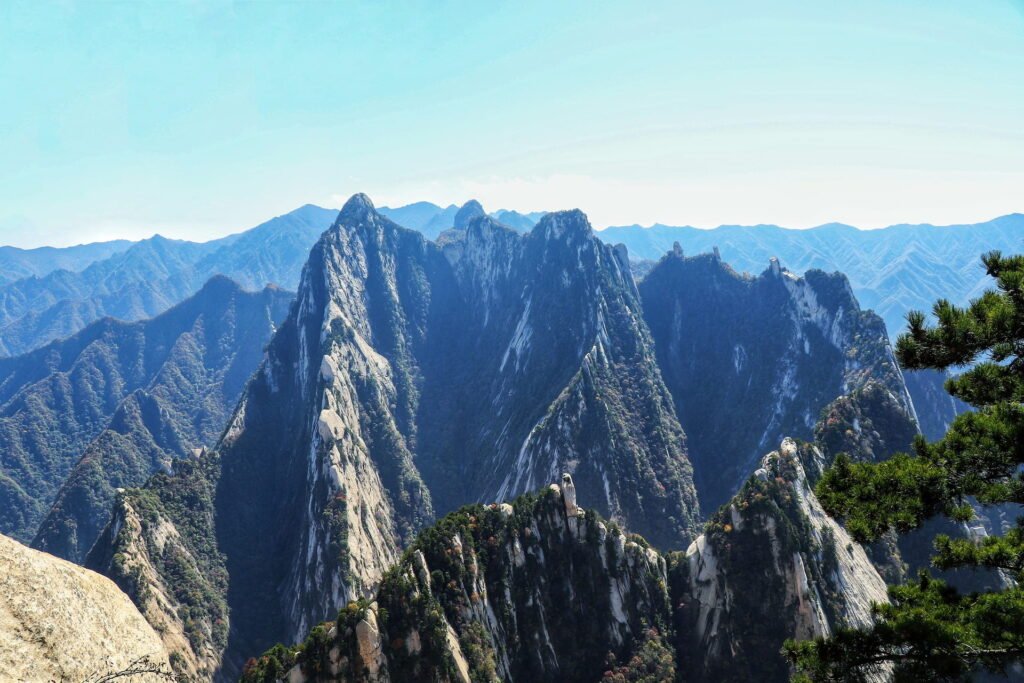
Mount Huashan, renowned as the world’s most precipitous mountain, is shrouded in legends. Its steepness is not only a defining characteristic but also its allure. Since ancient times, Huashan has been described as a single path, symbolizing its ruggedness. The uniqueness and perilousness of Huashan can be witnessed in its extraordinary rock formations, treacherous trails, enchanting water features, and breathtaking vistas.
As the sacred land of the mainstream Quanzhen sect of Chinese Taoism, Huashan holds the esteemed title of the “Fourth Heavenly Abode.” It is also widely revered as a deity among the Chinese populace, known as the God of Mount Huashan. The mountain boasts 72 partially suspended caves and over 20 Taoist temples, including notable ones like Yuquan Temple, Duolong Temple, Dongdao Temple, and Zhenyue Palace, which are designated as key Taoist sites of national importance.
Practical Information
- Chinese Name: 华山
- Location: Southern section of Yuquan Road, Huayin City, Weinan, Shaanxi Province
- Elevation: 2,154.9 meters (7,070 feet)
- Ticket Prices: March 1st to November 30th: 160 RMB, December 1st to February 28th: 100 RMB
- Best Time to Visit: April to October
- Recommended Travel Duration: 1-2 days
Unique Features and Natural Beauty
Embark on an awe-inspiring journey to Huashan, where ancient temples, perilous plank roads, and treacherous ravines await. Huashan offers a thrilling adventure for the daring traveler.
Xiyue Temple
Xiyue Temple, built during the Han Dynasty, is a significant site where emperors of successive dynasties worshiped the gods of Huashan. It is a key cultural heritage site under national protection in China. Known as the “Divine Temple of Huashan, Imperial Palace,” it is also renowned as the “Number One Temple of the Five Sacred Mountains.” Its grand scale and high standards are unparalleled by other Taoist temples.
Changkong Plank Road
With a length of over 100 meters, it is the biggest highlight of Huashan and is hailed as the “Number One Peril of Huashan.” The plank road is only about 30 centimeters wide, with one side hanging in mid-air without railings, while the cliff side is equipped with iron chains as handrails. This attraction is not open every day due to its high risk nature and strict weather requirements. It may remain closed in unfavorable weather conditions.
Qianchi Zhuang
Located above Huixin Stone, Qianchi Zhuang is the first treacherous area of Huashan. The cliff wall of the zhuang stands upright, allowing only two people to pass through at a time. Iron chains hang vertically on both sides with a slope of 70 degrees. There are over 370 steps from top to bottom, and the width does not exceed one’s satisfaction.
Baichi Xia
Baichi Xia, situated north of Qianchi Zhuang, is the second treacherous area encountered when ascending Huashan. It is a narrow and steep ravine-like path squeezed between sheer rock walls. In the middle, there is a giant stone descending from the sky with the inscription “Astonishing Heart Stone” carved on it, and visitors must pass beneath it.
Best Tour Routes
From North Peak to West Peak
Yuquan Courtyard – North Peak – Middle Peak – East Peak – South Peak – West Peak
Tips of North Peak to West Peak
Along the way, discover accommodations, restaurants, and panoramic views of the mountain peaks. From the lowest North Peak to the stunning West Peak, this adventure promises awe-inspiring sights and unforgettable memories.
From Yuquan Courtyard to North Peak
- Qianchi Zhuang and Baichi Xia are adjacent to each other, with a platform in between where you can rest and line up.
- After climbing Baichi Xia, you will reach Laojunligou, where the slope is steep. You can use both hands and feet to climb this section.
- The North Peak is the lowest among the five peaks of Huashan, and there is Yun Tai Mountain Villa near the mountaintop for accommodation.
From North Peak to Middle Peak
- Canglong Ridge has cliffs on both sides, but the slope is not steep, and there are iron railings on both sides for protection. You can climb while enjoying the scenery with peace of mind.
- Climbing up Canglong Ridge will lead you to Wuyun Peak, where there is a restaurant offering accommodation. You can rest and have a meal here.
- Beyond Wuyun Peak is Jinsuoguan, where you will find many golden locks, peace locks, and red prayer threads.
- The Middle Peak is located in the middle of the Southeast, Northwest three peaks, and from the summit, you can see the other three peaks.
From Middle Peak to East Peak
- The Yunti (Cloud Ladder) from Middle Peak to East Peak is the most challenging among all the vertical ladders in Huashan. It is recommended to hold onto the iron chain in the middle with both hands and climb up with your legs straddling the chains on both sides.
- The East Peak is the best location on Huashan to observe the sunrise. There is a restaurant offering accommodation, so if you want to rest or watch the sunrise, you can choose to stay here.
From East Peak to South Peak
- The first half of the Yaozifanshen (Kite Turning Over) is a bit more challenging, with small grooves carved on the rock wall being the only footholds in most places, and you need to descend with your back facing down.
- The Changkong Plank Road is visually more thrilling, with iron nails embedded in the cliff wall, iron chains hanging, and wooden planks forming the path.
- The summit of the South Peak is the highest point of Huashan, where you can overlook the entire landscape of the mountain.
From South Peak to West Peak
- The section from South Peak to West Peak is the shortest, and the scenery along the way is also quite good, with attractions such as Yingke Song, Cuiyun Palace, and Lianhua Cave.
- The summit of the West Peak is a single piece of lotus petal-shaped giant rock. Personally, I find the scenery of the West Peak to be the most beautiful among the five peaks.
Essential Tips for Mount Huashan Hiking
- Wear gloves. Mount Huashan has steep slopes and many areas require climbing with both hands and feet, so it is necessary to prepare a pair of gloves to grip the iron chains.
- Use a backpack. It is best to use a wide-shoulder backpack to avoid shoulder strain. Additionally, since both hands and feet are often used during the climb, a backpack is the most suitable option.
- Bring hiking poles. If you want to bring hiking poles, it is best to choose collapsible ones that can be stored in your backpack when not in use, freeing up your hands.
- Carry cash. The signal on the mountain may not be very good, so having cash on hand can help in case you need to buy something and there is no network for QR code payments.
Mount Emei
Mount Emei is not only one of the Four Sacred Buddhist Mountains in China but also one of the Ten Famous Mountains in China. It is renowned for its beautiful natural scenery, ancient Buddhist culture, abundant flora and fauna, and unique geological features. The four wonders of sea of clouds, sunrise, Buddha’s light, and sacred lamps, along with the Ten Scenic Spots of Mount Emei, fully testify to its reputation as the “most beautiful mountain under heaven.”
With an average elevation of over 1800 meters, Mount Emei offers a scenery unlike most other mountains. It boasts more than 30 high-altitude peaks, each with its own distinct features. Due to its high elevation, the mountain is shrouded in clouds and mist throughout the year, creating a surreal and enchanting atmosphere that makes visitors feel like they have entered a heavenly realm.

Practical Information
- Chinese Name: 峨眉山
- Location: Ming Shan South Road, Emeishan City, Leshan, Sichuan Province, China
- Elevation: 3,099 meters (10,167 feet)
- Ticket Prices: From January 16 to December 14: 160 RMB, From December 15 to January 15: 110 RMB
- Best Time to Visit: July to December
- Recommended Travel Duration: 1 to 3 days
Unique Features and Natural Beauty
Discover the magic of Mount Emei: the ethereal Sea of Clouds, majestic Sunrise, mystical Buddha’s Light, and enigmatic Sacred Lights. Experience breathtaking wonders and spiritual moments in one extraordinary journey.
Sea of Clouds
When the sky is clear, a vast expanse of clouds can be seen rising from the valleys and forests, resembling a large blanket of white feathers spread across the horizon. It creates a surreal and ethereal atmosphere, as if celestial beings are making their appearance.
Sunrise
While sunrise is a familiar sight, the sunrise at Mount Emei is particularly spectacular. As the sun rises, the golden rays illuminate the thousands of mountains and ridges. The fiery sun, the colorful clouds, and the snow-capped mountains in the west create a magnificent and breathtaking scene.
Buddha's Light
During the clear hours after rain, when the sunlight is bright and the sky is clear, the light reflects on the sea of clouds. You will see a colorful halo with red on the outside, purple on the inside, and a milky white glass-like center. As visitors step into the halo, their shadows move along with them. Interestingly, even when two people stand with their arms crossed, they cannot see each other within the halo.
Sacred Lights
On moonless nights, beneath the pitch-black She’shen Cliff, floating green light clusters appear. They twinkle and jump like countless stars, sometimes dispersing, sometimes gathering, rising and falling unpredictably, emanating an aura of mystery.
Best Tour Routes
Embark on your Mount Emei adventure with three distinct routes. Choose based on your physical stamina and desired experience. From challenging hikes to comfortable rides, explore the beauty and grandeur of Mount Emei in a way that suits you best.
Front Mountain Route
Baoguo Temple – Fuhu Temple – Qingyin Pavilion – Hongchunping – Xianfeng Temple – Xixiangchi – Leidongping – Jieyin Hall – Golden Summit
Tips of Front Mountain Route
- The walking distance is close to 50 kilometers, with a vertical ascent of nearly 3000 meters.
- This route is a significant test of physical endurance and mental strength, so most people choose to complete it in 2 days.
- Accommodations are available at Xixiangchi and Leidongping, but it is recommended to stay at Leidongping as it is more convenient for reaching the summit on the second day.
- For those who want to fully appreciate the beauty of Mount Emei, it is strongly recommended to take this route. Although it may be tiring, it will definitely be worth it.
Back Mountain Route
Qingyin Pavilion – Bailong Cave – Wannian Temple – Changlaoping – Chudian – Huayan Peak – Xixiangchi – Leidongping – Jieyin Hall – Golden Summit
Tips of Back Mountain Route
- The walking distance is 10 kilometers shorter compared to the Front Mountain route, but the vertical distance remains the same.
- This route is steeper, but individuals with good physical stamina can complete the ascent in a single day.
- The mountain scenery is not as good as the Front Mountain route, and because the mountain paths are steeper, this route is less frequently chosen by visitors.
Vehicle Route
Take a vehicle – Leidongping Station – Golden Summit
Tips of Vehicle Route
- This route is commonly taken by tour groups and is the least physically demanding route as it primarily involves traveling by vehicle.
- Take a bus from the central bus station directly to Leidongping, passing through Linggongli. The road is winding, with many 180-degree turns, covering approximately 40 kilometers. People prone to motion sickness are advised to bring motion sickness medication.
- Leidongping serves as a preliminary station for reaching the summit, located at an elevation of 2,430 meters. From here to Jieyin Hall, there is a 1.5-kilometer distance that must be covered on foot.
- After reaching Jieyin Hall, there are two options: the first is to take the cable car to the Golden Summit, with a ticket price of 65 yuan per person; the second is to walk, covering a distance of 6 kilometers with an elevation gain of approximately 600 meters.
Tips for a Safe and Enjoyable Experience
- Pay attention to the monkeys. The monkeys on Mount Emei are wild and may be aggressive, so do not provoke or interact with them to avoid getting injured.
- Ice cleats. If you visit Mount Emei in winter, it’s recommended to bring ice cleats for better traction and safety while climbing the mountain.
- Clothing. Regardless of whether it’s summer or winter, the temperature at the mountaintop is very low, so be sure to bring thick clothing.
- Raincoat. The weather on the mountain can be unpredictable, so it’s advisable to carry a raincoat in case of unexpected rain to prevent getting wet and potentially catching a cold.
Mount Qomolangma
Mount Everest, also known as Chomolungma, is the main peak of the Himalayas. It forms an arc-shaped mountain range, stretching approximately east to west. The northern slope of Mount Everest is within the territory of China’s Qinghai-Tibet Plateau, while the southern slope lies within Nepal.
The natural environment on Mount Everest is extremely harsh, characterized by freezing temperatures and extensive snow cover, making it an almost impossible task to climb. Humans are naturally curious about the unknown, and many people are intrigued by the breathtaking scenery atop Mount Everest.
As a result, numerous mountaineering enthusiasts gather here, seeking to challenge their limits. Many have successfully reached the summit. It is their spirit of pushing boundaries and longing to witness the magnificence of the summit that has inspired a large community of mountaineering and photography enthusiasts to come to this place.

Practical Information
- Chinese Name: 珠穆朗玛峰
- Location: Dingri County, Shigatse City, Tibet Autonomous Region, China
- Elevation: 8,848.86 meters (29,031.7 feet)
- Ticket Prices: 180 yuan per person
- Best Time to Visit: April to May, September to October
- Recommended Travel Duration: Depending on the specific circumstances
Unique Features and Natural Beauty
Discover the awe-inspiring Giant Pyramid-like Mountain, with towering peaks, stunning glaciers, captivating Flag Clouds, and the renowned Everest Base Camp. Embark on an unforgettable adventure in this extraordinary realm.
Giant Pyramid-like Mountain
Within a 20-kilometer radius, there are numerous peaks and ranges surrounding it. There are over 40 peaks with elevations exceeding 7,000 meters, including notable ones like the Lhotse Peak (8,516 meters, the world’s fourth-highest peak) located 3 kilometers to the south, the Cho Oyu Peak (7,589 meters) to the southeast, and the Makalu Peak (8,463 meters, the world’s fifth-highest peak) to the southeast. The Zhumulangma Peak is located 3 kilometers to the north with an elevation of 7,543 meters, while the Nupse Peak (7,855 meters) and Pumori Peak (7,145 meters) are situated to the west.
Natural Glaciers
Among the ridges and cliffs of these mountains, there are numerous massive ice towers, ice basins, and ice horn peaks. The longest glacier stretches up to 26 kilometers. The ice towers stand tall in various shapes, resembling sharp swords, ancient temple towers, ice tables, ice bridges, ice pillars, and ice caves. The ice cones resemble countless sharp swords thrust into the sky, and they also resemble various animal forms. In between, there are deep ice caves, winding ice rivers, creating a unique and magnificent sight.
Flag Clouds of Everest
Due to the tremendous height of Everest, its unique geographical location, and the surrounding environment of numerous tall snowy mountains, there are often unique, colorful, and ever-changing cloud formations appearing in the sky, resembling fluttering white flags hanging over the top. This is the distinctive spectacle known as the “Flag Clouds of Everest.”
Everest Base Camp
Established as a protected area to preserve the environment of the Everest core zone, it is located at an elevation of 5,200 meters, approximately 19 kilometers in a straight line from the summit. There are tents available for climbers and visitors, as well as lodges, teahouses, and shops. After resting at the base camp, climbers can continue their journey to summit Mount Everest.
Best Tour Routes
Due to the high risks involved in climbing Mount Everest, it is advisable for individuals who wish to climb Everest to thoroughly research various routes and ensure their own safety.
Essential Tips for Mount Everest Journey
- Do not take a bath. When going to Mount Everest, you will enter the highest region in Tibet, so avoid bathing or washing your hair for the first three days to prevent altitude sickness.
- Motion sickness medicine. If you are prone to motion sickness, it is recommended to bring some motion sickness medicine, as Mount Everest has numerous sharp turns and winding roads.
- Bring disposable toiletries. Accommodation conditions at the foot of Mount Everest are relatively poor, and many hotels do not provide these daily necessities.
- Thick clothing. The high altitude of Mount Everest results in significant temperature differences between day and night, so be sure to bring items such as down jackets, warm hats, and scarves for insulation.
Changbai Mountain
Changbai Mountain, named for its white rocks and accumulated snow, is renowned as the “First Peak Under Heaven with Thousand-year Snow and Ten-thousand-year Pines.” The scenic area is a famous tourist destination known for its reputation as a “sacred mountain, holy water, marvelous forest, and celestial fruit,” and it is also the birthplace of the Manchu people in China. In the Qing Dynasty, it was regarded as a “sacred place,” where emperors personally or through appointed ministers would come to Jilin Ula (now Jilin City) to pay homage to Changbai Mountain.
In spring, Changbai Mountain is still covered with snow, and amidst the vast expanse of white snow, trees are just budding with new leaves, and flowers are beginning to bloom. It showcases the grandeur of winter and the vibrant scenery of spring.
In summer, Changbai Mountain is enveloped in a green world, with white clouds reflected in Tianchi (Heavenly Lake), creating a scene reminiscent of a fairyland. Looking out at the various peaks of Changbai Mountain, one cannot help but marvel at the magnificence and wonder of nature.
Autumn is the most beautiful season of Changbai Mountain, with pleasant weather and breathtaking scenery that captivates visitors. Immersed among the mountains, one can experience the vibrant colors of Changbai Mountain, feel the refreshing autumn breeze, and breathe in the fresh air of nature.
In winter, Changbai Mountain is blanketed by a thick layer of snow, resembling a white cotton coat, which brings a sense of tranquility and joy, allowing all worries to fade away. The mountain peaks are adorned with snowflakes, and the wind scatters them, creating an air of mystery over Tianchi.

Practical Information
- Chinese Name: 长白山
- Location: Located in the southeastern part of Jilin Province, bordering Heilongjiang Province to the north and Liaoning Province to the southwest, and neighboring North Korea and Russia to the southeast and east respectively.
- Elevation: 2,749 meters (9,019 feet)
- Ticket Prices: North Slope Ticket: 225 yuan/person, West Slope Ticket: 214 yuan/person
- Best Time to Visit: July to September, November to March
- Recommended Travel Duration: 2-3 days
Unique Features and Natural Beauty
Discover the enchanting Tianchi Lake, the mystical Jinchan Resting Peak, the awe-inspiring Changbai Waterfall, the breathtaking Ice Valley Grand Canyon, and the rejuvenating Longxian Hot Springs of Changbai Mountain. Embark on an unforgettable adventure in this natural paradise.
Tianchi Lake of Changbai Mountain
Changbai Mountain, formed by geological tectonic movements 12 million years ago, features Tianchi Lake, which was the volcanic vent for magma eruptions. Through multiple eruptions, it shaped into a giant umbrella-shaped landform. When the volcano became dormant, springs overflowed, forming a vast water surface of nearly ten square kilometers. In summer, Tianchi Lake melts, presenting a deep blue color, while in winter, it freezes, exhibiting a glistening white ice surface. Surrounded by sixteen peaks and experiencing a changeable climate, Tianchi Lake often reveals the presence of mythical creatures swimming in its waters.
Jinchan Resting Peak
With an elevation of 2,640 meters, Huagai Peak is a solidified volcanic cone after the eruption of Tianchi Lake, appearing in a yellowish-brown color. When standing at the site of the Tianchi Lake stele inscribed by Deng Xiaoping and looking to the left, one can see a portion of its peak resembling a giant three-legged golden toad with its head raised towards the sky. The golden toad symbolizes prosperity and good fortune, and catching a glimpse of it here is believed to bring luck.
Changbai Waterfall
Surrounded by mountains, Tianchi Lake features a steep cut between Tianhuofeng and Longmenfeng, where the lake water flows gently, passes through Niulangdu, and converges four cold springs together, resulting in increased water volume. Before reaching the precipice, the water is split by huge rocks into two streams, plunging down a 68-meter drop.
The waterfall displays a pure white color as it hangs on the steep cliffs of green stone, creating mist and fog that rises into the air. It flows incessantly throughout the year, forming a deep pool of more than 20 meters at the base, producing a thunderous roar. At the confluence of the rushing currents lies the source of the Erdao Baihe River and Songhua River.
Ice Valley Grand Canyon
The grand canyon is located below the waterfall, extending to the hot spring pool, forming a U-shaped valley with a width of about 300 meters and a depth ranging from 100 to 200 meters.
This valley was shaped by the Quaternary glaciation, eroding loose volcanic formations and deepening the collapsed structure. Around Tianchi Lake, there are numerous ice moraine landforms of various sizes, radiating down the mountain slopes. Among them, the Erdao Canyon is the widest, with the distribution of rivers and hot springs, making it a famous U-shaped ice valley in the geological history of the world.
Longxian Hot Springs
Located below the waterfall, to the right of the Erdao Baihe River, there is a cluster of high-temperature hot springs known as Longxian Hot Springs. The water temperature ranges from 60 to 82 degrees Celsius, covering an area of over 1,000 square meters and featuring more than ten spouting outlets, also known as Julong Hot Springs.
The hot springs continuously emit steam and contain mineral ions such as iron, copper, magnesium, and manganese. These minerals accumulate on the surface, forming layers of mineralization in shades of reddish-brown, emerald green, deep purple, and golden yellow, resembling a natural oil painting hanging in the grand canyon.
Best Tour Routes
Discover the North Slope Route with stunning attractions like Tianchi Lake, Waterfall, Hot Springs, and more. Alternatively, experience the West Slope Route for panoramic views of Tianchi Lake, Alpine Garden, and the Grand Canyon. Choose your adventure in this scenic paradise.
North Slope Route
Tourist Distribution Center – Transfer Center – Tianchi Lake – Transfer Center – Waterfall – Hot Springs – Little Tianchi – Greenyuan Float – Underground Forest
Tips of North Slope Route
- The most beautiful view of Tianchi Lake can be seen from the North Slope, which was developed earliest.
- Among the three slopes, the North Slope has the most attractions.
- The estimated duration of the visit is about 5 hours.
West Slope Route
Tourist Distribution Center – Tianchi Lake Transfer Center – 1442-step Staircase – Tianchi Lake – Alpine Garden – Grand Canyon
Tips of West Slope Route
- The West Slope offers a larger range of Tianchi Lake view and was developed relatively later, maintaining the appearance of the original forest.
- To reach Tianchi Lake, you need to climb over 1400 steps. Visitors with elderly or children should take note of this.
- During winter, the stairs are often icy, and there is an additional fee of 135 yuan to take a snowmobile to Tianchi Lake.
Tips for Exploring the Spectacular Beauties
- Mount Changbai has four slopes: East, South, West, and North. Within China, only the West, South, and North slopes are accessible. The South slope is open for only 2 to 3 months a year, while the West and North slopes are open year-round.
- It is recommended to purchase a combination ticket in advance for each scenic area: Distribution Center Ticket + Scenic Area Ticket + Bus Ticket.
- Tickets for the North and West slopes are not interchangeable. Purchase tickets based on the desired destination.
- Changbai Mountain Airport is near the West slope, while Changbai Mountain Railway Station is near the North slope. The distance between the North and West slopes is approximately 100 kilometers.
- From the North slope to the West slope, you can take a train from Changbai Mountain Station to Songjianghe Station.
Jade Dragon Snow Mountain
In the Naxi language, Jade Dragon Snow Mountain is called “Oulu,” which means “Heavenly Mountain.” Its thirteen snow-capped peaks stretch endlessly, resembling a “giant dragon” soaring and dancing, hence the name “Jade Dragon.” Additionally, due to its predominant rock formations of limestone and basalt, starkly contrasting in black and white, it is also known as the “Black and White Snow Mountain.” It is considered a sacred mountain by the Naxi people, believed to be the embodiment of their protective deities known as the “Sanduo.”
What magic does Jade Dragon Snow Mountain hold? When you are left speechless by the awe-inspiring rays of sunlight illuminating the golden mountains, when you witness vast meadows stretching through clouds and mist, when you reach out and realize the starry sky is right before your eyes, you suddenly understand why everyone must visit Jade Dragon Snow Mountain at least once.

Practical Information
- Chinese Name: 玉龙雪山
- Location: 15 kilometers north of Lijiang Ancient Town, Yulong County, Lijiang City.
- Elevation: 5,596 meters (18,360 feet)
- Ticket Prices: 100 yuan per person
- Best Time to Visit: November to March
- Recommended Travel Duration: 1-2 days
Unique Features and Natural Beauty
Immerse yourself in the breathtaking beauty of pristine landscapes, cascading waterfalls, alpine meadows, and panoramic views of snow-capped mountains. Discover the rich cultural heritage and natural splendor of this enchanting region.
Blue Moon Valley
Blue Moon Valley is located at the eastern foothills of Jade Dragon Snow Mountain. It is named so because the water appears blue on sunny days, and the valley takes the shape of a crescent moon. The color of the lake surface varies depending on different angles. There are also many small waterfalls flowing down around the lake, creating unique and beautiful scenery that can be captured effortlessly.
Glacier Park
It is a rare geological formation created by glacial erosion during the Quaternary period. The park consists of caves and grottoes formed by glacial erosion. During autumn, winter, and spring, the park is covered in a silver-white blanket of snow. In summer, as the snow melts, visitors can witness glaciers that formed over 40,000 years ago, providing a close encounter with the snow-capped mountains.
Maoniuping
With high-altitude snowfields and the flowing Blackwater River, Maoniuping offers a picturesque view of the pristine forest landscape. The landscape is diverse and vibrant, with the presence of Yi and Tibetan villages where the locals engage in animal husbandry. The villagers maintain traditional customs, creating a strong ethnic and cultural atmosphere. Maoniuping, at an elevation of 3,700 meters, is an ideal spot to admire the thirteen peaks of Yulong Snow Mountain.
Yunshanping
Yunshanping is a high-altitude alpine meadow located halfway up the main peak of Jade Dragon Snow Mountain at an elevation of 3,240 meters. It resembles a small pasture hidden within the pristine fir forest, appearing as a lush green carpet at the foot of the Jade Dragon Snow Mountain from a distance. Every year, young people from different ethnic minorities gather here to sing folk songs and perform traditional dances, welcoming visitors from all directions.
Yushuizhai
In this scenic area, there is a clear mountain spring that gushes out from a hidden cave beneath two ancient pentagonal maple trees, forming a series of cascading waterfalls. Yushuizhai is also the birthplace of the Dongba religion of the Naxi ethnic group. It houses an exhibition hall displaying ancient Dongba scriptures, puppets, ritual objects, and other cultural relics, making it the museum with the largest collection of Dongba cultural artifacts.
Ganhaizi
Ganhaizi is the closest and best place to admire the panoramic view of Yulong Snow Mountain. From here, visitors can see the thirteen peaks of Yulong Snow Mountain arranged in a north-to-south direction, showcasing their grandeur and radiance. With the distant view of the snow-capped mountains, the vast meadow is scattered with low pine trees, and occasional yaks pass by, creating a beautiful scenery reminiscent of a highland pasture.
Best Tour Routes
Entrance Gate – Ganhaizi – Glacier Park – Blue Moon Valley – Maoniuping
Tips of Tuor Routes
- The round-trip cable car to Glacier Park costs 140 yuan, while the round-trip cable car to Maoniuping costs 65 yuan.
- It is recommended to visit Blue Moon Valley in the morning as the scenery facing the sunlight is more spectacular.
- If you have enough time, you can visit both Yunshanping and Maoniuping. If time is limited, it is suggested to only visit Maoniuping.
Essential Tips for a Safe and Enjoyable Visit
- Purchase oxygen cylinders in advance. Oxygen cylinders at the foot of the mountain are relatively cheap, around 10-15 yuan, while they cost 60 yuan per bottle on the mountain.
- Take sun protection measures. The ultraviolet rays in Yunnan are strong, so it is recommended to bring sunglasses, a hat, and sunscreen.
- Don’t sleep immediately. After descending the mountain, it is recommended to take a rest in a well-ventilated area to allow the brain to adjust to the normal oxygen levels.
- Prepare warm clothing. The temperature in Glacier Park is relatively low, so it is best to wear a windproof thick jacket.
- Pre-oxygenate in advance. It is advisable to start oxygenation before taking the cable car to allow the body to adjust, rather than waiting until discomfort arises before using oxygen.
Mount Wutai
Mount Wutai, the foremost of China’s four sacred Buddhist mountains, is renowned for its rich Buddhist culture both domestically and internationally. It houses the largest existing complex of Buddhist ancient architecture in East Asia and even the world. Comprising five main peaks, Mount Wutai harmoniously integrates natural topography with Buddhist culture. It epitomizes the profound reverence for Buddhism, encapsulating the worship of nature’s mountains and exemplifying the philosophical concept of “harmony between heaven and man” in Chinese culture. For over 1,600 years, Wutaishan has served as a vibrant center for Buddhist Manjusri worship, representing a unique and dynamic combination of cultural landscapes.
The five peaks of Wutaishan encircle each other, towering above the clouds. They are devoid of trees on their summits and present a flat and broad terrain resembling earthen platforms, hence the name “Wutaishan” (literally meaning “Five Terrace Mountain”). With its eastern, western, southern, northern, and central peaks, Wutaishan exhibits a landscape characterized by overlapping mountain ranges, intersecting valleys and rivers, and lush green forests. The interplay between basins and mountain ranges creates a vivid, cool, and pleasant environment, making it an ideal destination for sightseeing and summer retreats.
Practical Information
- Chinese Name: 五台山
- Location: Wutai County, northeastern part of Xinzhou City, Shanxi Province
- Elevation: 3,061.1 meters (10,042 feet)
- Ticket Prices: 135 yuan per person
- Best Time to Visit: May to September
- Recommended Travel Duration: 1-3 days
Unique Features and Natural Beauty
Discover the revered temples of Wutai Mountain: Wuye Temple, Shuxiang Temple, Tayuan Temple, and Xiantong Temple. Immerse yourself in the spiritual essence and ancient history of this sacred site.
Wuye Temple
Wuye Temple is the most popular temple in Wutai Mountain. It is dedicated to the protector deity of Mount Wutai, known as Wuye. It is also called Wanfoge (Ten Thousand Buddha Hall) because the hall houses ten thousand Buddha statues.
Shuxiang Temple
Wutai Mountain is the sacred place of Manjushri Bodhisattva, and Shuxiang Temple is considered the ancestral temple of Manjushri Bodhisattva. It houses the largest indoor statue of Manjushri on Wutai Mountain, reaching a height of 9.78 meters (32 feet). It is believed to be the most efficacious temple for academic pursuits.
Tayuan Temple
Adjacent to Wuye Temple is Tayuan Temple, which is known for its iconic structure, the Dabaita. It enshrines the relic of Shakyamuni Buddha, earning it the name Shakyamuni’s Relic Pagoda. Tayuan Temple is a nationally protected cultural site, and the ticket price is ten yuan.
Xiantong Temple
Xiantong Temple is the original and oldest temple in Wutai Mountain and the second oldest temple in Chinese history. Its construction dates back to the 11th year of the Eastern Han Dynasty. There is a saying at Wutai Mountain: “To understand Xiantong Temple is to understand the entire Buddhist history of Wutai Mountain.”
Best Tour Routes
Day 1: Dawenshu Temple – Shuxiang Temple – Wuye Temple – Tayuan Temple – Xiantong Temple – Pusa Peak – Luohou Temple – Dailuo Peak – Guanghua Temple
Day 2: Pu Hua Temple – Fanxian Mountain – Nanshan Temple – Zhenhai Temple
Tips of Tour Routes
- Wuye Temple, Xiantong Temple, Tayuan Temple, Luohou Temple, Pusa Peak, and Guanghua Temple are all located together.
- There are additional entrance fees for four temples: Tayuan Temple, Xiantong Temple, Pusa Peak (10 yuan), and Dailuo Peak (8 yuan).
- Staying near Wuye Temple can be slightly noisy. There is a parking lot nearby. People start queuing at Wuye Temple as early as 4 am.
- If you intend to take a bus to peak, it is recommended to depart early in the morning. Buy tickets at the parking lot below Dailuo Peak.
Guidelines and Etiquette for Visiting Mount Wutai
- Pre-registration is required for self-driving. If you plan to drive to Mount Wutai, you need to register your vehicle information on the “Hui You Wutaishan” official WeChat account before entering.
- No smoking in the temples. Smoking inside the temple premises is disrespectful to the Buddha statues.
- Visit the temples in a clockwise direction. Enter the main hall from the left side entrance and exit from the right side entrance.
- No need to bring your own incense. Temples that allow incense burning will provide incense, while temples that prohibit incense burning will not allow it even if you bring your own.
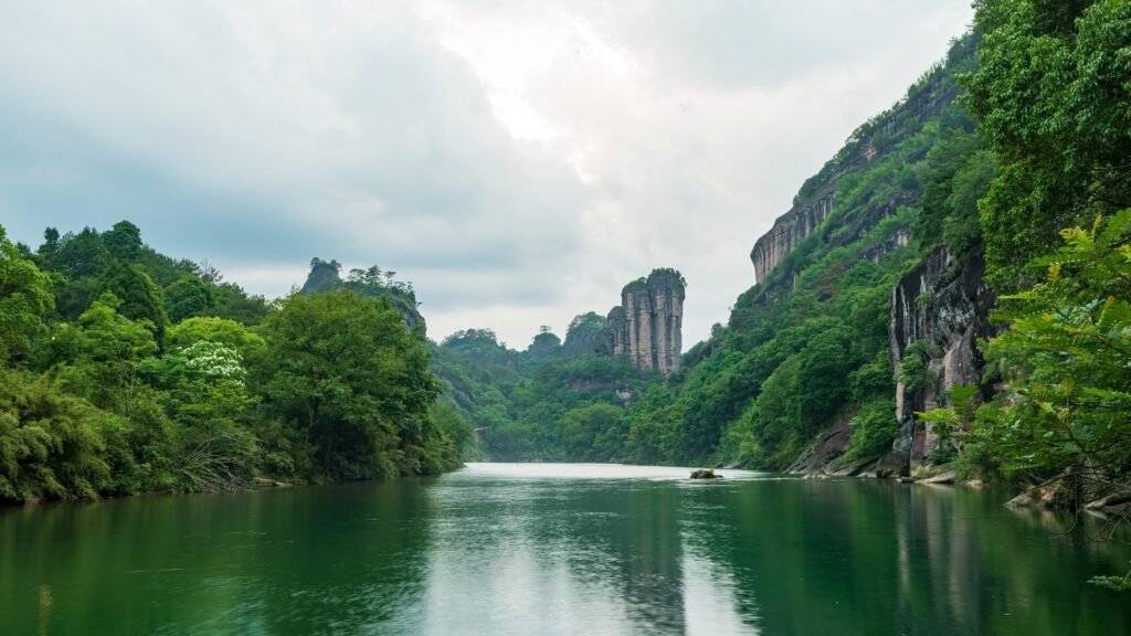
Mount Wuyi
Wuyi Mountain is a dual UNESCO World Heritage site, recognized for its cultural and natural significance. It boasts the best-preserved and most diverse ecosystem in the same latitude region, with 2,527 plant species and nearly 5,000 species of wildlife.
Renowned for its stunning landscapes and abundant resources, Mount Wuyi is often referred to as a “natural museum,” an “insect world,” a “bird paradise,” and the “kingdom of snakes.” Its fame is well deserved.
When discussing Wuyi Mountain, one cannot overlook the renowned “Da Hong Pao” tea, which holds the title of the “King of Rock Tea” among Wuyi’s tea varieties. Brewing just a few leaves releases a captivating aroma. Many visitors come to Wuyi Mountain solely to savor the taste of this exquisite tea.
Practical Information
- Chinese Name: 武夷山
- Location: Located at the junction of Jiangxi and northwestern Fujian provinces.
- Elevation: 2,158 meters (7,080 feet).
- Ticket Prices: 140 yuan per person.
- Best Time to Visit: June to November.
- Recommended Travel Duration: 1-3 days.
Unique Features and Natural Beauty
Explore the highlights of Wuyi Mountains. Immerse yourself in the natural beauty, tea culture, stunning performances, serene temples, and picturesque ancient architecture.
Tianyou Peak
In addition to its charming natural scenery, this place also features tea gardens, academies, and cliff stone carvings, showcasing the perfect combination of natural and cultural heritage in Wuyi Mountains.
Jiuqu Stream
You can take a bamboo raft to enjoy the breathtaking mountain and water views of Wuyi Mountains. It’s a leisurely and pleasant experience as the stream water is exceptionally clear, resembling a filtered scene.
Impression Dahongpao
With a 360-degree rotating seat, this live performance showcases the tea culture of Mount Wuyi, providing an immersive experience that allows you to feel the rich tea culture of the region.
Baiyun Temple
A perfect spot to witness sunrise and sea of clouds, especially in the morning when the mist surrounds the area, creating a heavenly ambiance and offering an unforgettable sunrise experience.
Xiamei Ancient Village
Experience the ambiance of a tranquil riverside village. The well-preserved ancient architecture exudes a sense of historical charm, with every brick and tile carrying a sense of bygone eras. It’s a truly picturesque ancient village.
Best Tour Routes
Day 1: Arrival at Mount Wuyi → Tianyou Peak → Yixiantian → Impression Dahongpao
Day 2: Jiuqu Stream drifting → Yunv Peak → Wuyi Palace → Zhizhian
Day 3: Baiyun Temple → Huxiao Rock → Dahongpao Scenic Area → Rock and Bone Fragrance Walking Trail → Return journey
Tips of Tour Routes
- Advance reservation is required for Jiuqu Stream drifting, so avoid purchasing tickets on the same day.
- Please refrain from using flash photography during the Impression Dahongpao show.
- The mountain road to Tianyou Peak is extremely steep, with many sections approaching a 90-degree angle.
Convenient Stay and Culinary Delights in Mount Wuyi
- It is recommended to stay at Sanggu Resort, which is conveniently located and provides easy access to the attractions.
- Wuyi Mountains offer a variety of delicious food worth recommending, such as Dahongpao Tea Fish, Tea Oil Fragrant Frog with Rice, and Crispy Bamboo Shoots with Sliced Pork.
- From Wuyishan North Railway Station, you can take a bus to reach Wuyi Mountains.
- From Nanping Railway Station, you can take the tourist special bus route K1 to reach Wuyi Mountains.
Conclusion
China’s top 10 famous mountains are a testament to the awe-inspiring beauty and cultural significance of this remarkable country. From Huangshan to the Himalayas, each mountain offers unique features and natural splendor. Plan your visit carefully, consider practical information, and embark on a journey that promises unforgettable experiences. Let the summit splendor of China’s mountains leave an indelible mark on your heart and inspire your sense of adventure.


")